Environmental baseline characterisation of the springs in Hot Springs Valley, NT
This project will conduct a field campaign to collect detailed data on the geology, hydrogeology and ecology of the Hot Springs Valley to augment data collected in previous surveys.
The Hot Springs Valley is located on Tanumbirini Station and lies to the Northeast of the Beetaloo Sub-basin. It is within the headwaters of the Cox River catchment and includes several spring complexes.
The Hot Springs Valley is a relatively understudied area that holds significant environmental and cultural value. Environmentally, this natural phenomenon may sustain unique ecosystems, and culturally these springs are connected to Traditional Owners with many potentially important cultural sites surrounding these springs.
Collecting baseline environmental data to comprehensively characterise the springs will provide an important evidence base for protection and management of this environmentally and culturally significant area.

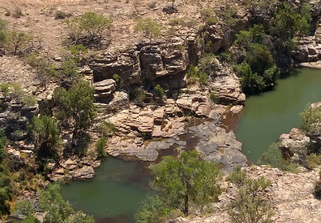
Gorge Spring – one of several springs in the Hot Springs Valley in the Northern Territory.

Some of the springs in the hot springs Valley feature naturally occurring seeps of methane and ethane.
This information will provide an important evidence base for protection and management of this environmentally and culturally significant area, extend the existing knowledge of this unique system, and provide a baseline prior to any potential development of gas resources in the nearby Beetaloo Sub-basin.
These data will be used to develop a model for the likely sources of water and gas in the springs, the spatio-temporal evolution of the seepage and the discharge pathways. The model will allow a better understanding of how the springs may be impacted by development. The data and model will inform future water planning and management and to inform industry and government on future groundwater and emissions monitoring programs.
[Music plays and an image appears of a split circle, and photos move through of CSIRO activities in either side of the circle, and then the circle morphs into the CSIRO logo]
[Image changes to show an aerial view of a foggy landscape at dawn, and then the image changes to show an aerial view of bushland as the camera pans out, and text appears: CSIRO’s GISERA would like to thank the Northern Land Council and the Traditional Owners of the Hot Springs Valley for their assistance in the planning for the research project field work, and for accompanying and welcoming the researchers to the site]
[Image changes to show an aerial view of bushland and spinifex plains as the camera pans left, and then the image changes to show another aerial view of bushland, and text appears: We recognise that the Hot Springs Valley is of high environmental, cultural and spiritual significance, and the research could not have been undertaken without their support]
[Image changes to show an aerial view of a 4WD driving on a dirt road, and then image changes to show a person on a steep rocky outcrop beside water as the camera pans in on the person]
Cameron Huddlestone-Holmes: My name is Cameron Huddlestone-Holmes and I’m a research scientist with CSIRO’s Gas Industry Social and Environmental Research Alliance, or GISERA.
[Image changes to show an aerial view of water in a gorge as the camera rotates left]
We’re on a station in the very north eastern edge of the Beetaloo Sub-basin in the Northern Territory.
[Image changes to show Cameron Huddleston-Holmes talking to the camera, and then image changes to show Cameron unrolling a map on a table, camera zooms in on his hands, and text appears: Dr Cameron Huddlestone-Holmes, Queensland and Northern Territory Lead, GISERA, Geologist]
CSIRO’s GISERA establishes projects by listening to community concerns around activities associated with the gas industry.
[Images move through to show Cameron talking, the map flying up hiding Dr Cindy Ong from view, a female pointing at the map with Cameron, and then Cameron’s hand pointing at colours on a rock]
The nature of these springs is one of those issues that has been identified through our engagement with community, but also through other research done by the Northern Territory Government and others.
[Music plays as image changes to show an aerial view of bushland with rocky outcrops and paths rivers of water has gouged into the earth]
[Image changes to show Dr Ema Frery talking as she pulls out a small item from the 4WD rear window and then lifting a bag into the 4WD rear window]
Dr Ema Frery: It’s time to go.
[Image changes to show Ema getting into the driver’s seat and the closing the door]
So here in Hot Springs Valley, the rocks can be used as an archive of what happened in the past.
[Image changes to show Ema’s hand on the steering wheel, and then the image changes to show the side profile of Ema’s face]
And it’s really important to understand what happened.
[and then the image changes to show Ema talking to the camera, and text appears: Dr Ema Frery, Geologist]
And when I say in the past it can be thousands of years ago as well as just more recent seasons.
[Image changes to show a side view of Ema bending over to study the ground of the steep rocky outcrop]
What I’m studying is what the other team are going to study at present day.
[Image changes to show Ema standing up from examining the rocky outcrop and walking towards the camera smiling]
So I’m studying the same thing in the past.
It’s like a window.
[Image changes to show Ema talking to the camera]
A window to what? Past events.
[Music plays as images move through to show Ema making notes, a rear view of Ema walking the base of the rocky outcrop, Ema walking along the top of the outcrop, and Ema talking to the camera]
The analysis of those rocks in the lab will tell us what was the signature of the fluids that have been circulating in the past.
[Image changes to show Ema’s hand writing in a notebook, ]
So we will understand from where the water was coming, what was the composition of the fluids?
[Images move through to show Ema’s hands using a geological compass, Ema walking while looking at a rock wall, Ema’s hand holding a rock, Ema talking, and then Ema talking to the camera]
We could even make assumptions of the temperature of the fluid at that time and we will know when it was circulating.
And also if we do datings at different in different area, we will understand what was the flux.
[Music plays as image changes to show leaves of a tree canopy of a tall gum tree swaying in a gentle breeze]
[Images move through to show gum leaves, colleagues walking in the bush, Ema listening to a female, a male talking to Ema and the female, and Axel Suckow standing with colleagues while looking about]
Axel Suckow: So my name is Axel, Axel Suckow to be precise, and by training I’m an environmental physicist, which means that I investigate natural systems with the methodology of physics.
[Music plays as image move through to show Axel with colleagues, hands holding an iPad, a 4WD driving a bush track, views of vehicles parked near a gorge]
So here we investigate the groundwater system, which means we want to understand how fast the water flows, how much recharge is, how it mixes between different aquifers.
[Music plays as images move through to show Axel talking to the camera, a colleague giving a shovel to Axel standing on a cliff edge, and then Axel walking along a rocky outcrop, and text appears: Dr Axel Suckow, Environmental Tracer and Noble Gas Scientist]
It is often declared as the age of groundwater but that is a little bit more complex because groundwater always mixes.
[Images move through to show a male standing beside a hot spring, hands connecting terminals on a battery in the spring, Axel crouched beside rock wall and laughing, and views of a hose in the spring]
Therefore we want to know how fast does it flow from recharge from the moment the rain has been falling up to the moment it comes either out of the spring or we sample it in the bore.
[Image changes to show views of Axel, views of Axel talking to the camera, views of hands and colleagues handling research equipment, water filling bottles, and Colleagues working together]
It is very important to study this here in this area because there is a conflicting interest between farmers on one side, agricultural development but also gas industry has an interest here and we have sacred sites or groundwater dependent ecosystems and all these need to have enough water and we have to restrain, of course, some of them.
[Music plays as images move through to show water in a gorge, aerial view of colleagues walking on the rock gorge as the camera pans up to the water below, and an aerial view of the gorge with water]
Dr Matthias Raiber: So what’s most fascinating about these areas, firstly, the remoteness of this area that we are here in the Northern Territory.
[Image changes to show Dr Matthias Raiber recording data, and then the image changes to show Matthias talking with a female as they check collected data on a hand held device]
We sometimes go to remote area, but this is very special to us and it’s a very beautiful space as well, very beautiful spot.
[Images move through to show gloved hands holding up a test tube, hands adjusting gloves, gloved hands using a syringe on a bottle, and then Matthias filling a bottle from a hot spring]
And we want to have to give the information to preserve this space and see if there are any changes in the future to see what can be done about it.
[Image changes to show Matthias talking to the camera, and then the image changes to show a close view of Matthias holding the test tube up to the camera, and text appears: Dr Matthias Raiber, Hydrogeologist]
So another area that’s really fascinating for us is just working together with the different teams and also colleagues from other organisations as well.
[Images move through to show a research sensor device submerged in the spring, Ema standing under a tree, Matthias talking, a female moving the sensor, and Colleagues working together]
So we, in many projects we just collect samples for chemistry or environmental tracers, but it’s not in every project that we’re doing that we can look at all the different components ecology, geology, chemistry.
[Music plays as image changes to show Matthias and a male filling up a water bottle, and then the image changes to show Matthias’ hand shaking the bottle]
[Image changes to show Matthias holding a GPS device, and then the image changes to show Matthias using the device]
So we collect chemistry samples here today.
[Images move through to show Matthias using the device, and then multiple views of Matthias working with a male at a table using a laptop and a phone torch at night]
We also work together with the geologists who look at the rocks and work together with colleagues to collect samples of the water.
[Image changes to show four colleagues around the table working together outside under lights]
And we also work together with the team that analyses the fugitive emissions concentrations.
[Music plays as image changes to show a male picking up a backpack and putting it over his shoulder.
]
[Images move through to show colleagues at the campsite getting ready for an expedition, a female walking up to colleagues, Ema holding and iPad, and then Ema and a female walking up to Matthias]
Dr Cindy Ong: Why this research is very important is because we do not have a lot of information for the area and this is a very culturally and environmentally sensitive area.
[Images move through to show views of Cindy talking with colleagues, views of Cindy, hands holding a smart phone, views of colleagues walking, and then Cindy talking to the camera, and text appears: Dr Cindy Ong, Hot Springs Valley Project Lead, Greenhouse Gas Emissions Scientist]
And having a comprehensive baseline is really important for community decision making, for industry decision making, monitoring the impacts and basic understanding of this whole area.
[Image changes to show Cindy holding a small case and a smartphone, and then the image changes to show Cameron looking at a map with colleagues]
We will be measuring methane and ethane.
[Images move through to show Cindy looking down, Cindy talking to the camera, and then a male using research equipment in a spring]
Usually if we see a sample that has methane and ethane, it relates to a deeper source or thermogenic source.
[Image changes to show an aerial view of colleagues walking sparse bushland, an aerial views of the campsite]
What excites me about this study is that we are truly collecting a baseline of the area.
[Image changes to show an aerial view of water in a gorge]
Nobody really knows so much about it.
Where does that come from? That’s my biggest question.
[Music plays as image changes to show the CSIRO logo above text: GISERA, Gas Industry Social and Environmental Research Alliance, gisera.csiro.au]
[Image changes to show the CSIRO, Australian Government Coat of Arms, various State and Territory logos, and various other sponsoring logos below text: GISERA, Gas Industry Social and Environmental Research Alliance, gisera.csiro.au ]
CSIRO research in the Hot Springs Valley, Northern territory
– GISERA video


