Baseline groundwater and seismicity, northern Perth Basin
CSIRO scientists will employ non-invasive methods to monitor the occurrence and distribution of earthquakes (seismicity) and groundwater depths at which the ground is saturated with water across the northern Perth Basin in Western Australia. The northern Perth Basin makes up the northern half of the Perth Basin, which is a north to north–northwest trending, onshore and offshore sedimentary basin extending about 1,300 km along the southwestern margin of the Australian continent.
Scientists will use passive monitoring methods (seismic waves) to detect subtle changes in subsurface rock properties, primarily driven by fluctuations in groundwater depths within alluvial and confined aquifers.
Research results will gather data that will distinguish between natural and anthropogenic factors causing variations in groundwater depths and seismic activity, and provide valuable insights that can help to improve water use management for the agricultural community, resources sector and regulators.
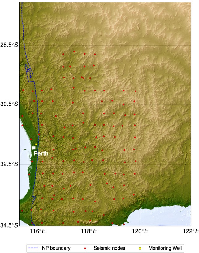
map north perth basin
The survey map. The red dots are the seismic nodes from the WAArray, with available data from November 2022 to December 2023.
The yellow square is one monitoring well used for measuring groundwater level (hydraulic head, mAHD).
The dashed blue line is the boundary of the Perth Basin.
Reports and papers
Establishing Baseline Groundwater and Natural Seismicity Levels across the Northern Perth Basin with Passive Seismic Data – Interim Report 2
This interim report provides progress for subsurface velocity changes caused by groundwater level variations and natural seismicity event detection and localising in the Northern Perth Basin. We use seismic data recorded by the WA-Array seismic array in 2022-2023, recently deployed by the Geological Survey of Western Australia (GSWA).
Establishing Baseline Groundwater and Natural Seismicity levels across the Northern Perth Basin with Passive Seismic Data – Interim Report 1
This interim report describes progress for groundwater monitoring and baseline natural seismicity levels in the North Perth Basin, using seismic data from a dense seismic array recently deployed by the Geological Survey of Western Australia (GSWA).
Extras
Baseline groundwater and seismicity of northern Perth Basin
This fact sheet describes a CSIRO research project which uses non-invasive monitoring methods to establish baseline groundwater and natural seismicity levels across the northern Perth Basin. Results will provide insights to help communities, the resources sector and regulators improve water use management in the region.
Project progress
This project is 60% complete.