Methane seepage in the Surat Basin
This project will detect and measure methane seeping from underground in the Surat Basin, and identify sources of methane to provide a baseline of methane emissions on a regional scale.
This will result in a methane emissions data set that can be used to compare changes in methane concentrations as coal seam gas production in the Surat Basin increases.
This project was expanded from the original scope in November 2015. The atmospheric monitoring, originally proposed to be one baseline station, was extended to a network of two CSIRO stations and at least one industry station, all linked to the same concentration scales.
This enhancement analyses and prepares additional data from the new and emerging monitoring stations in a network across the Surat Basin for a more definitive source estimation. It will quantify contributions from sources through forward modelling using existing and new information on inventories and that from infrastructure based monitoring and will develop an inverse modelling framework to better constrain the main source areas and emissions using data from the new and emerging monitoring stations and information from forward modelling.
Transcript for Methane seepage in the Surat Basin
[Music plays and the GISERA (Gas Industry Social & Environmental Research Alliance) logo appears on screen]
[Text appears: Methane seepage in the Surat Basin – research update]
[Image changes to show Stuart Day, Senior Research Scientist, CSIRO Energy Flagship]
Stuart Day: The aim is to determine what the background emissions of methane are from this area where there is a lot of Coal Seam Gas activity at the moment.
[Image changes to show a coal seam gas plant]
The gas production in this region is likely to increase over the next few years significantly so it’s important to establish what the emissions are naturally and from other industries as well so that you can determine what the effect of the CSG industry is on the Greenhouse emissions from the area.
[Image changes to show a helicopter taking off]
Well the primary method is using an airborne sensor but we are also using ground base surveys to calibrate and validate that instrument’s data.
[Image changes to show Stuart inside a vehicle collecting data. Camera zooms in on the screen of a methane analyser, which is measuring methane concentrations]
[Stuart off screen “So, it’s taking a sample every few seconds”]
So we’re driving along with a sensitive methane analyser in our vehicle and were comparing the methane concentrations we measure on the ground with those we measure from the air.
[Image changes to show the helicopter in flight]
[Stuart off screen “You can see the numbers updating on the screen there”]
Today we’re trialling a new technology for looking at natural methane emissions from the ground. The purpose of it is to try and identify these seeps over a broad area fairly quickly.
[Image changes to show the helicopter in the sky and the vehicle with Stuart in it travelling alongside a coal seam gas plant]
It’s part of a larger project where we are looking at natural methane emissions across the Surat Basin to establish a baseline in the CSG fields.
[Image changes to show Cindy Ong, Senior Research Scientist, CSIRO Minerals Flagship]
Cindy Ong: The coal seam gas wells are spread across the Surat Basin. What we’re trialling today is a remote sensing technique which will provide us with a spatially comprehensive picture of the seepage level and allow us to be able to understand or identify areas where the seepages are.
[Image changes to show aerial footage of the landscape, which includes crops, a river and feeding plots]
The traditional method of actually monitoring the seepages is actually point measurement and for a very extensive area such as the Surat basin where we need to understand what the overall measurement is we are not able to provide enough of these point measurements to cover it and that’s why we’re actually using this remote sensing technique.
[Image changes to show the helicopter in flight and an aerial shot of a coal seam gas plant]
Stuart Day: The work we are doing today is largely about detecting methane sources but it’s also very important to be able to measure how fast that methane is being emitted.
[Image changes to show pictures of properties and then changes to show pelicans in the water]
So the other component of this project is aimed at establishing two fixed monitoring sites throughout the Surat Basin, where they’ll measure atmospheric concentrations of methane for up to 12 months or more and that will give us the information we need to calculate how fast the methane is being emitted from the region.
[Music plays and the GISERA logo appears on screen]
[Sponsors logos appear on screen, from left to right – CSIRO, Australia Pacific LNG and QGC A BG Group business. Text appears at the bottom of the scree: www.gisera.org.au]
[New text appears: Additional footage courtesy of Australian Broadcasting Corporation Library Sales]
Methane seepage in the Surat Basin – GISERA video
Reports and papers
Quantifying methane emissions from Queensland's coal seam gas producing Surat Basin using inventory data and a regional Bayesian inversion
This peer reviewed paper was published in Atmospheric Chemistry and Physics, the interactive open access journal of the European Geosciences Union. Extending research developed in the GISERA project “Characterisation of Regional Fluxes of Methane in the Surat Basin, Queensland” this paper describes how CSIRO researchers developed and applied an efficient regional Bayesian inverse model, that uses hourly in-situ methane concentrations from two sites and modelled dispersion to quantify the magnitude and distribution of emissions.
Characterisation of Regional Fluxes of Methane in the Surat Basin, Queensland
The project aimed to quantify methane emissions across the Surat Basin using a “top-down” analysis, where methane concentration measurements are combined with atmospheric dispersion modelling to infer net emissions. This final report for the GISERA project “Characterisation of Regional Fluxes of Methane in the Surat Basin, Queensland” provides detailed description of research activities, methodology and results.
Characterisation of Regional Fluxes of Methane in the Surat Basin, Phase 3.2
This report describes interim results of the measurements and modelling activities of Phase 3 of the project. The results presented in this interim report demonstrate the potential to infer net regional emissions of methane across the Surat Basin with an inverse modelling approach, using a combination of methane concentration measurements and plume transport modelling. To the authors’ knowledge, this study is the first to infer regional emissions of methane in this way.
Characterisation of Regional Fluxes of Methane in the Surat Basin, Phase 3.1: monitoring results
The continuous monitoring results – installation, commissioning and operation of two field stations and preliminary data.
Characterisation of Regional Fluxes of Methane in the Surat Basin, Phase 2: A pilot study of methodology to detect and quantify methane sources
Findings of Phase 2 where several methods for detecting methane emission sources and estimating the emission rates were examined during field trials conducted within the Surat Basin.
Characterisation of Regional Fluxes of Methane in the Surat Basin, Phase 1: A Review and Analysis of Literature on Methane Detection and Flux Determination
Phase 1 of the project was a ‘Survey, Review and Analysis of Literature’ with the aim of tailoring a set of methods to the specific problem of locating and quantifying methane seeps.
Extras
Characterisation of regional fluxes of methane in the Surat Basin, Queensland
Presentation to the Queensland Knowledge Transfer Session in Brisbane, June 2019
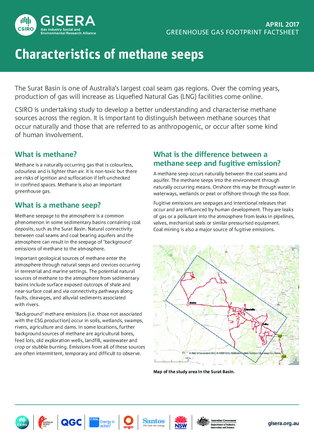
Characteristics of methane seeps
It is important to distinguish between methane sources that occur naturally and those that are referred to as anthropogenic, or occur after some kind of human involvement.
CSIRO conducting world’s best practice methane emissions research
For the first time in Australia, CSIRO is developing a dedicated methane research program in the Surat Basin to identify and locate sources of naturally occurring methane emissions, and in some cases, estimate how fast methane flows from these sources.
Project Progress
This project is complete.
Project proposal
A detailed description of the project, budget and research milestones.