CSIRO’s GISERA in the Top End
Since 2018, CSIRO’s Gas Industry Social and Environmental Research Alliance (GISERA) has been instrumental in advancing the understanding of environmental impacts within a component of the Northern Territory’s resources sector.
As the region sees increasing exploration and extraction activities, GISERA’s research has gathered valuable baseline data, designed robust monitoring methods and frameworks, and identified pathways for more sustainable practices.
This body of work includes a mix of completed, ongoing, and upcoming research projects, all aimed at minimising impacts on biodiversity, water resources, and local communities.

Dr Cameron Huddlestone-Holmes
Dr Cameron Huddlestone-Holmes
“GISERA’s work has been critical in building our understanding of the environment of the Beetaloo Region, and how that may be impacted by resource development,” says Dr Cameron Huddlestone-Holmes, Principal Research Scientist with CSIRO Energy, and GISERA Territory Leader.
“We can see that work having an impact through the way the resource industry operates and how the regulator approaches its role. The outputs of our research also provide valuable information for the local and broader community.”
GISERA’s completed projects have provided a critical foundation of knowledge for guiding future resource development in the Beetaloo region of the Northern Territory.
These studies have focused on a variety of interconnected themes, including water management, biodiversity conservation, and methane emissions, with an emphasis on supporting informed decision-making by industry and community stakeholders.
Ground and surface waters
One of the most significant areas of research has been the study of groundwater and surface water resources in the Northern Territory, particularly in regions that may be impacted by shale gas extraction.
A foundational study in the Beetaloo Sub-basin enabled better understanding of the geochemical properties, recharge rates and recharge mechanisms of groundwater.
The study sampled and analysed groundwater to create a set of baseline data against which any potential impacts caused by the gas industry can be measured.
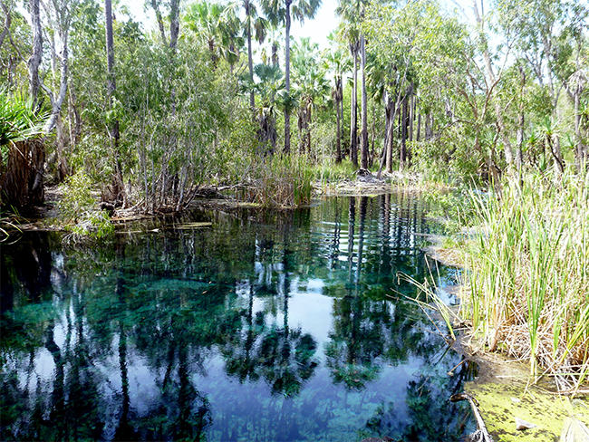
Bitter Springs in Elsey National Park, NT
Bitter Springs in Elsey National Park, NT, are an example of groundwater dependent ecosystems
Another project examined how chemicals used in onshore gas operations behave in local soils and aquifers. Encouragingly, microbial communities in both environments were found to break down these chemicals, often within weeks, although degradation in aquifers occurred more slowly.
“A major concern for communities is what happened with the chemicals that are used in hydraulic fracturing,” says Dr Huddlestone-Holmes. “Our research showing that these chemicals are broken down by microbial communities in the environment is an important finding that helps us understand the potential impacts in the unlikely event of a spill or release.”
Equally important was a study that tracked the fate of hydraulic fracturing fluids and geogenic hydrocarbons in flow-back water produced after fracturing and in surface facilities. Results showed that most compounds break down quickly and pose minimal environmental risk, though further assessment of one biocide is recommended.
Biodiversity
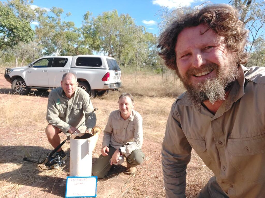
The Northern Territory’s unique biodiversity – much of it still poorly documented – has been a key focus of GISERA’s research in the Beetaloo Sub-basin. One study delivered the first characterisation of stygofauna in the region, uncovering a diverse array of subterranean species that are part of groundwater ecosystems. Using both traditional sampling and DNA-based techniques, researchers discovered species likely new to science and generated valuable baseline data on these groundwater-dependent ecosystems.
“Stygofauna are an of research that has provided an opportunity to study a little-known aspect of the region,” says Dr Huddlestone-Holmes. “It’s brought some real science excitement and discoveries about an ecosystem that is truly unique. We’ve built a great foundation of knowledge, and the initial study has led to follow-up projects.”


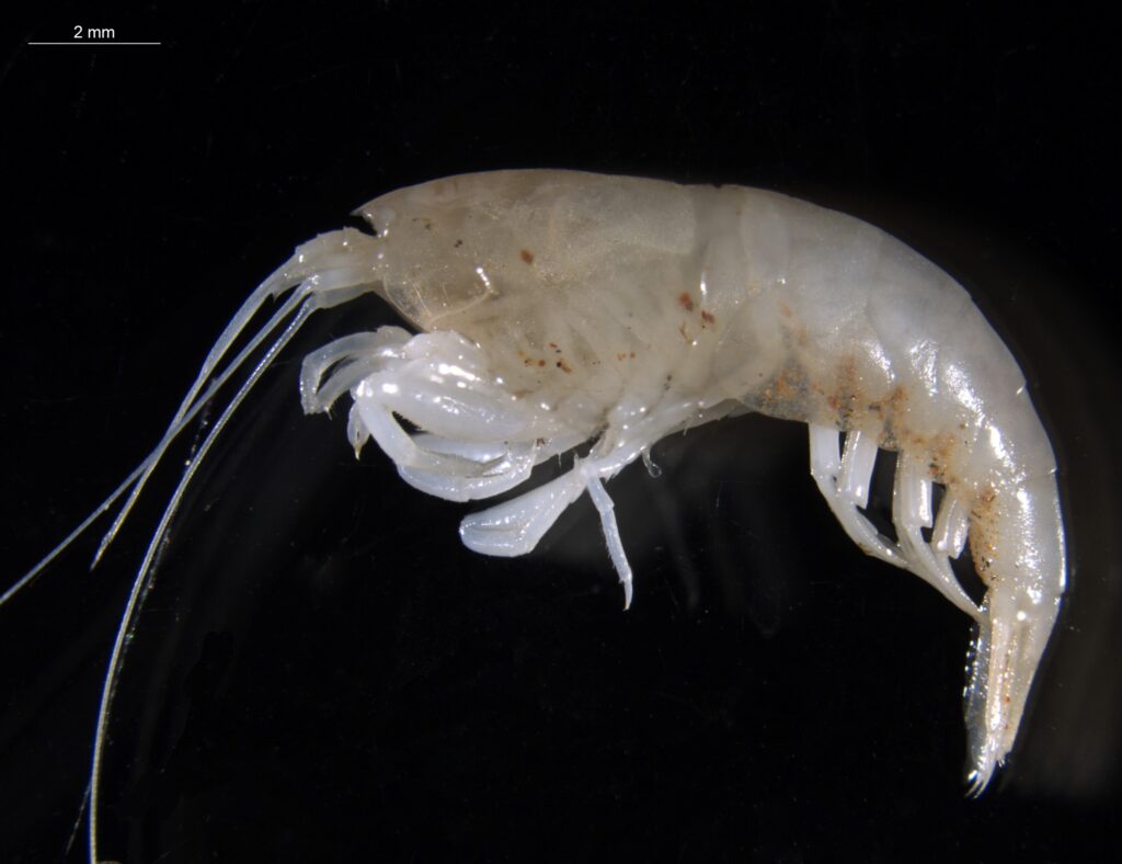
Above, clockwise from top left: The stygofauna research team in the field; a catching jar for holding netted specimens; two types of crustaceans – Parabathynellidae; and the apex predator of the stygofaunal world, Parisia unguis.
The latest stygofauna research project, completed in May this year, has significantly improved knowledge of stygofauna diversity and species composition within the Beetaloo Sub-basin. Video evidence confirmed that stygofauna, particularly shrimp, are primarily associated with cavities and screened bore sections with suitable openings for movement.
Another project addressed growing community concerns about the impact of roads, pipelines and other infrastructure on native flora and fauna. Researchers investigated how vegetation connectivity, habitat patch size and road type affect biodiversity. The study also looked at animal road mortality and developed evidence-based options to minimise future risks from infrastructure development.
A fourth project completed this year used UAV-LiDAR drone technology and spaceborne remote sensing to monitor the structural condition of vegetation in the Beetaloo, and confirmed this new technique could be used to monitor habitat changes over vast areas.


Above, clockwise from left: CSIRO scientists used drones fitted with LiDAR sensors; a section of the Beetaloo Sub-basin digitally mapped by drones; the sentinel 2 satellite operated by the European Space Agency provided data; and a 3D image of Beetaloo Sub-basin vegetation created using LiDAR sensor technology. The colour scale shows height above ground level.
Together, these projects are helping to fill critical knowledge gaps about biodiversity in the Northern Territory. The findings help to inform planning and decision-making by government, industry and communities, and will be vital to ensuring that future development in the Beetaloo region can be balanced with the protection of sensitive habitats and species.
Greenhouse gases and climate impacts
GISERA’s research has played a key role in establishing a clear picture of greenhouse gas emissions in the Northern Territory, particularly in relation to methane – a significant contributor to climate change. One project created the first seasonal baseline for methane concentrations in the Beetaloo Sub-basin, using mobile survey technology to measure levels during the dry, wet and fire seasons. The findings showed methane concentrations consistent with atmospheric background levels, with slight variations linked to sources such as cattle, wetlands and fires.
A second project focused on reducing future emissions by improving gas well integrity. Researchers tested new materials and sealing techniques to address methane leakage from microfractures and gaps in well casings. The results support best practice for minimising fugitive emissions and enhancing well integrity.
To look further ahead, a third study assessed potential life cycle emissions from future gas production in the Beetaloo region. Researchers modelled five different development scenarios and explored offset options and mitigation strategies. The analysis found that most emissions from four of the five scenarios could be mitigated or physically abated using current technologies available in Australia.
Together, these projects provide robust data for managing emissions as energy development in the region evolves.
Land and infrastructure
A number of projects over the last seven years have delivered important insights to guide land use planning, infrastructure design and well decommissioning practices in the Northern Territory. One study explored options for long-term monitoring of decommissioned onshore gas wells, reviewing current technologies and practices to support best-practice management and reduce long-term risks to groundwater and the environment.
In a related project, researchers investigated the long-term ‘self-sealing’ potential of shale formations in the Beetaloo Sub-basin. This research found that certain shale layers may naturally close over time following well decommissioning, reducing the risk of fluid movement and supporting long-term well integrity.
[The CSIRO logo animates through shots of various landscapes before finishing on the logo.]
A cross-section of a remote, semi-arid Australian landscape. A gas pipe structure appears, extending vertically into the ground. Layers of earth are coloured in browns, greys, and blues to represent different rock strata.
After gas wells reached the end of their serviceable life, industry operators must carefully seal and decommission them to prevent future leaks.
[A well casing animation shows the steel and cement layers that seal off the wellbore from surrounding rock. A crack appears in the pipes showing a potential leak. The sky animates from day to night several times to show the passing of time.]
But what if a new pathway forms over time through cracks, fractures or along the wellbore itself, allowing gas to escape? How can we ensure these wells maintain their integrity and resist leaks for many decades after decommissioning?
[3 scientists in lab coats are in deep discussion.]
That’s exactly the question we’re tackling head on here at CSIRO.
[A map of Australia, we push in on the Northern Territory and the Beetaloo Sub-basin area appears. The cities of Katherine and Darwin are also shown.]
Our work focuses on the Beetaloo Sub Basin, south east of Katherine in the Northern Territory.
[A female scientist, Dr Elaheh Arjomand addresses the camera directly.]
Strict regulations are in place in the Northern Territory to ensure the proper installation of cement plugs, and to safely decommission the petroleum wells.
[A well casing animation shows the steel and cement layers that seal off the wellbore from surrounding rock. A crack appears in the pipes showing a potential leak.]
However, over the time the bond between the cement casing and surrounding shale rock may deteriorate, potentially compromising the integrity of wells and increasing the risk of contamination.
[Dr Elaheh uses two different machines for tests. Then addresses the camera again.]
That’s why we are investigating whether the slow movement of shale, which is also called creep, can naturally close the gaps and enhance the sealing capacity of rock over time.
[An animated cutaway view shows a cross-section of the earth. Layers of earth are coloured in browns, greys, and blues to represent water and different rock strata. A measuring line drops down showing the depth of the Kyalla Shale barrier from 1000m deep and extending for 500m. Text appears identifying the composition of the shale layer as clay and quartz. The pipeline then animates in, with arrows showing the natural creep and pressure imposed on the pipe.]
One of the formations is being studied for its potential as a natural barrier is Kyalla Shale formation in the Beetaloo Sub Basin.
Kyalla Shale is a thick rock layer composed of fine grained materials such as clay and quartz. Our research shows that chemical treatments can accelerate the natural creep of Kyalla Shale, enhancing its sealing capacity and contributing to long term well integrity during decommissioning.
[Dr Elaheh addresses the camera again. Then b-roll shots of her interacting with different machines in her laboratory.]
When Kyalla Shale is exposed to certain chemical solutions, it softens, and it deforms more easily. These solutions basically alter the way that clay and fluid interact, which leads to breaking down the minerals and changing the rock’s microscopic structure. Some of these chemicals also reduce the friction between shale layers, allowing them to slide and settle more easily. As a result, Kyalla Shale creeps more, especially when exposed to water-based solutions, reducing its strength but increasing its flexibility.
[The animation resumes, showing a predictive model of gas flow underground. It starts with a cracked pipe and reverting to an uncracked pipe as the shale creeps in.]
The camera pulls back to show the cross-section of the earth. The gas pipe extends vertically into the ground. Layers of earth are coloured in browns and greys.
This allows the rock to fill the gaps and prevent the movement of fluids and form an additional barrier during decommissioning.
What we are looking for is a robust natural barrier that seals the gap around the wellbore, to complement those traditional and essential methods of sealing during decommissioning.
[Closing visuals: A CSIRO-logo and the following text – “GISERA – Gas Industry Social and Environmental Research Alliance. gisera.csiro.au.”]
Want to know more? Visit our website.
Kyalla Shale in the Beetaloo Sub-basin, NT – GISERA video
To better understand how gas development could affect transport networks, a third project used CSIRO’s Transport Network Strategic Investments Tool (TraNSIT) to analyse freight flow impacts and road use under various development scenarios. The results will support improved road safety and lower environmental impacts from increased heavy vehicle movement.
In a fourth project, researchers used cutting-edge spatial modelling to apply previous GISERA research to land management. By developing a ‘digital twin’ of a 256 km² case study area, researchers demonstrated how augmented reality tools can support infrastructure design, erosion control and stakeholder engagement across landscapes undergoing early gas exploration.
And one of GISERA’s most recently completed projects in the Northern Territory established a baseline for natural seismic activity in the Beetaloo Sub-basin. This data provides a valuable reference point for detecting any future seismic changes linked to gas development.
In-progress and upcoming projects
In many of the projects completed since 2018 a key finding is the need for continued research and long-term monitoring.
Several in-progress and upcoming projects continue to build on the strong foundation established over GISERA’s first seven years.
These include studies into methane emissions from well construction and completion activities, the environmental impacts of wastewater disposal (both aiming to refine understanding of potential environmental consequences associated with shale gas extraction), and the environmental baseline characterisation of the remote and spectacular Hot Springs Valley.
Furthermore, GISERA’s recent approval of research into Indigenous socio-economic development in the Northern Territory’s resource sectors highlights the importance of inclusive approaches to development. This study will explore how the region’s energy industry can better align with the aspirations of local Indigenous communities, creating more equitable socio-economic outcomes.
“Some of our upcoming projects are really exciting,” says Dr Huddlestone-Holmes. “The project focused on Hot Springs Valley is an opportunity to bring together a broad range of disciplines from CSIRO to do a baseline study of this ecologically and culturally important site. We’ve got experts in atmospheric emissions, ecologists, groundwater and geology all coming together to understand that and describe it really well.”
[Music plays and an image appears of a split circle, and photos move through of CSIRO activities in either side of the circle, and then the circle morphs into the CSIRO logo]
[Image changes to show an aerial view of a foggy landscape at dawn, and then the image changes to show an aerial view of bushland as the camera pans out, and text appears: CSIRO’s GISERA would like to thank the Northern Land Council and the Traditional Owners of the Hot Springs Valley for their assistance in the planning for the research project field work, and for accompanying and welcoming the researchers to the site]
[Image changes to show an aerial view of bushland and spinifex plains as the camera pans left, and then the image changes to show another aerial view of bushland, and text appears: We recognise that the Hot Springs Valley is of high environmental, cultural and spiritual significance, and the research could not have been undertaken without their support]
[Image changes to show an aerial view of a 4WD driving on a dirt road, and then image changes to show a person on a steep rocky outcrop beside water as the camera pans in on the person]
Cameron Huddlestone-Holmes: My name is Cameron Huddlestone-Holmes and I’m a research scientist with CSIRO’s Gas Industry Social and Environmental Research Alliance, or GISERA.
[Image changes to show an aerial view of water in a gorge as the camera rotates left]
We’re on a station in the very north eastern edge of the Beetaloo Sub-basin in the Northern Territory.
[Image changes to show Cameron Huddleston-Holmes talking to the camera, and then image changes to show Cameron unrolling a map on a table, camera zooms in on his hands, and text appears: Dr Cameron Huddlestone-Holmes, Queensland and Northern Territory Lead, GISERA, Geologist]
CSIRO’s GISERA establishes projects by listening to community concerns around activities associated with the gas industry.
[Images move through to show Cameron talking, the map flying up hiding Dr Cindy Ong from view, a female pointing at the map with Cameron, and then Cameron’s hand pointing at colours on a rock]
The nature of these springs is one of those issues that has been identified through our engagement with community, but also through other research done by the Northern Territory Government and others.
[Music plays as image changes to show an aerial view of bushland with rocky outcrops and paths rivers of water has gouged into the earth]
[Image changes to show Dr Ema Frery talking as she pulls out a small item from the 4WD rear window and then lifting a bag into the 4WD rear window]
Dr Ema Frery: It’s time to go.
[Image changes to show Ema getting into the driver’s seat and the closing the door]
So here in Hot Springs Valley, the rocks can be used as an archive of what happened in the past.
[Image changes to show Ema’s hand on the steering wheel, and then the image changes to show the side profile of Ema’s face]
And it’s really important to understand what happened.
[and then the image changes to show Ema talking to the camera, and text appears: Dr Ema Frery, Geologist]
And when I say in the past it can be thousands of years ago as well as just more recent seasons.
[Image changes to show a side view of Ema bending over to study the ground of the steep rocky outcrop]
What I’m studying is what the other team are going to study at present day.
[Image changes to show Ema standing up from examining the rocky outcrop and walking towards the camera smiling]
So I’m studying the same thing in the past.
It’s like a window.
[Image changes to show Ema talking to the camera]
A window to what? Past events.
[Music plays as images move through to show Ema making notes, a rear view of Ema walking the base of the rocky outcrop, Ema walking along the top of the outcrop, and Ema talking to the camera]
The analysis of those rocks in the lab will tell us what was the signature of the fluids that have been circulating in the past.
[Image changes to show Ema’s hand writing in a notebook, ]
So we will understand from where the water was coming, what was the composition of the fluids?
[Images move through to show Ema’s hands using a geological compass, Ema walking while looking at a rock wall, Ema’s hand holding a rock, Ema talking, and then Ema talking to the camera]
We could even make assumptions of the temperature of the fluid at that time and we will know when it was circulating.
And also if we do datings at different in different area, we will understand what was the flux.
[Music plays as image changes to show leaves of a tree canopy of a tall gum tree swaying in a gentle breeze]
[Images move through to show gum leaves, colleagues walking in the bush, Ema listening to a female, a male talking to Ema and the female, and Axel Suckow standing with colleagues while looking about]
Axel Suckow: So my name is Axel, Axel Suckow to be precise, and by training I’m an environmental physicist, which means that I investigate natural systems with the methodology of physics.
[Music plays as image move through to show Axel with colleagues, hands holding an iPad, a 4WD driving a bush track, views of vehicles parked near a gorge]
So here we investigate the groundwater system, which means we want to understand how fast the water flows, how much recharge is, how it mixes between different aquifers.
[Music plays as images move through to show Axel talking to the camera, a colleague giving a shovel to Axel standing on a cliff edge, and then Axel walking along a rocky outcrop, and text appears: Dr Axel Suckow, Environmental Tracer and Noble Gas Scientist]
It is often declared as the age of groundwater but that is a little bit more complex because groundwater always mixes.
[Images move through to show a male standing beside a hot spring, hands connecting terminals on a battery in the spring, Axel crouched beside rock wall and laughing, and views of a hose in the spring]
Therefore we want to know how fast does it flow from recharge from the moment the rain has been falling up to the moment it comes either out of the spring or we sample it in the bore.
[Image changes to show views of Axel, views of Axel talking to the camera, views of hands and colleagues handling research equipment, water filling bottles, and Colleagues working together]
It is very important to study this here in this area because there is a conflicting interest between farmers on one side, agricultural development but also gas industry has an interest here and we have sacred sites or groundwater dependent ecosystems and all these need to have enough water and we have to restrain, of course, some of them.
[Music plays as images move through to show water in a gorge, aerial view of colleagues walking on the rock gorge as the camera pans up to the water below, and an aerial view of the gorge with water]
Dr Matthias Raiber: So what’s most fascinating about these areas, firstly, the remoteness of this area that we are here in the Northern Territory.
[Image changes to show Dr Matthias Raiber recording data, and then the image changes to show Matthias talking with a female as they check collected data on a hand held device]
We sometimes go to remote area, but this is very special to us and it’s a very beautiful space as well, very beautiful spot.
[Images move through to show gloved hands holding up a test tube, hands adjusting gloves, gloved hands using a syringe on a bottle, and then Matthias filling a bottle from a hot spring]
And we want to have to give the information to preserve this space and see if there are any changes in the future to see what can be done about it.
[Image changes to show Matthias talking to the camera, and then the image changes to show a close view of Matthias holding the test tube up to the camera, and text appears: Dr Matthias Raiber, Hydrogeologist]
So another area that’s really fascinating for us is just working together with the different teams and also colleagues from other organisations as well.
[Images move through to show a research sensor device submerged in the spring, Ema standing under a tree, Matthias talking, a female moving the sensor, and Colleagues working together]
So we, in many projects we just collect samples for chemistry or environmental tracers, but it’s not in every project that we’re doing that we can look at all the different components ecology, geology, chemistry.
[Music plays as image changes to show Matthias and a male filling up a water bottle, and then the image changes to show Matthias’ hand shaking the bottle]
[Image changes to show Matthias holding a GPS device, and then the image changes to show Matthias using the device]
So we collect chemistry samples here today.
[Images move through to show Matthias using the device, and then multiple views of Matthias working with a male at a table using a laptop and a phone torch at night]
We also work together with the geologists who look at the rocks and work together with colleagues to collect samples of the water.
[Image changes to show four colleagues around the table working together outside under lights]
And we also work together with the team that analyses the fugitive emissions concentrations.
[Music plays as image changes to show a male picking up a backpack and putting it over his shoulder.
]
[Images move through to show colleagues at the campsite getting ready for an expedition, a female walking up to colleagues, Ema holding and iPad, and then Ema and a female walking up to Matthias]
Dr Cindy Ong: Why this research is very important is because we do not have a lot of information for the area and this is a very culturally and environmentally sensitive area.
[Images move through to show views of Cindy talking with colleagues, views of Cindy, hands holding a smart phone, views of colleagues walking, and then Cindy talking to the camera, and text appears: Dr Cindy Ong, Hot Springs Valley Project Lead, Greenhouse Gas Emissions Scientist]
And having a comprehensive baseline is really important for community decision making, for industry decision making, monitoring the impacts and basic understanding of this whole area.
[Image changes to show Cindy holding a small case and a smartphone, and then the image changes to show Cameron looking at a map with colleagues]
We will be measuring methane and ethane.
[Images move through to show Cindy looking down, Cindy talking to the camera, and then a male using research equipment in a spring]
Usually if we see a sample that has methane and ethane, it relates to a deeper source or thermogenic source.
[Image changes to show an aerial view of colleagues walking sparse bushland, an aerial views of the campsite]
What excites me about this study is that we are truly collecting a baseline of the area.
[Image changes to show an aerial view of water in a gorge]
Nobody really knows so much about it.
Where does that come from? That’s my biggest question.
[Music plays as image changes to show the CSIRO logo above text: GISERA, Gas Industry Social and Environmental Research Alliance, gisera.csiro.au]
[Image changes to show the CSIRO, Australian Government Coat of Arms, various State and Territory logos, and various other sponsoring logos below text: GISERA, Gas Industry Social and Environmental Research Alliance, gisera.csiro.au ]
CSIRO research in the Hot Springs Valley, Northern territory
– GISERA video
“I’m also really excited that we will be collaborating with research partners at the University of Queensland, and working closely with local Indigenous communities to get a better understanding of their interactions with the gas industry. That’s going to be very important work.”
With an ongoing commitment to environmental and social sustainability, GISERA continues to lead the way in research that supports informed decision-making in the Northern Territory’s energy sector. Through its comprehensive body of work, GISERA has contributed valuable data on land and water management, biodiversity protection, and the mitigation of climate impacts.
As the Northern Territory’s energy landscape evolves, future GISERA’s projects will build on past insights to ensure resource development proceeds in ways that respect both environmental values and cultural priorities. This growing body of knowledge offers a strong foundation for sustainable energy practices and long-term protection of the region’s unique ecosystems.
“The point is approaching where there is a big decision to be made on whether to go ahead with the investment required for development in the Beetaloo,” says Dr Huddlestone-Holmes.
“CSIRO doesn’t hold a position on that decision – but if development does take place, we look forward to providing the scientific information to support decision making in communities, government, and the industry itself.”