New CSIRO research to reveal Narrabri from 400 metres underground
Beneath the Narrabri region in New South Wales are highly complex hydrogeological formations – an intriguing yet challenging setting for CSIRO groundwater research scientists aiming to improve community understanding of these ancient underground systems.
The Narrabri region in northern NSW is home to cotton and cattle grazing communities as well as the Pilliga Forest and the spectacular national parks of the volcanic Nandewar mountain range.
It’s also home to the proposed Santos Narrabri Gas Project, which has State and Federal approval and could involve up to 850 coal seam gas wells being drilled in the Pilliga Forest.
CSIRO’s Gas Industry Social and Environmental Research Alliance (GISERA) has approved a series of research projects in the Narrabri region designed to address community concerns about potential impacts of gas development on important groundwater resources.
These research programs focus on the role of faults and volcanic intrusions as potential hydrogeological connectivity pathways between the deeper coal bearing formations, and the shallower Great Artesian Basin and alluvium aquifers that are vitally important for agriculture and the environment.
Current research
The current research is led by CSIRO groundwater scientist Dr Matthias Raiber who described the Narrabri region as “geologically very interesting and complex.”
“Here we have Great Artesian Basin aquifers overlying the coal-bearing formations of the Gunnedah Basin and underlying the alluvial aquifers of the Murray Darling Basin,” Dr Raiber said. “In addition, we have volcanic aquifers of the Nandewar and Warrumbungle volcanic centres to the north and south.”
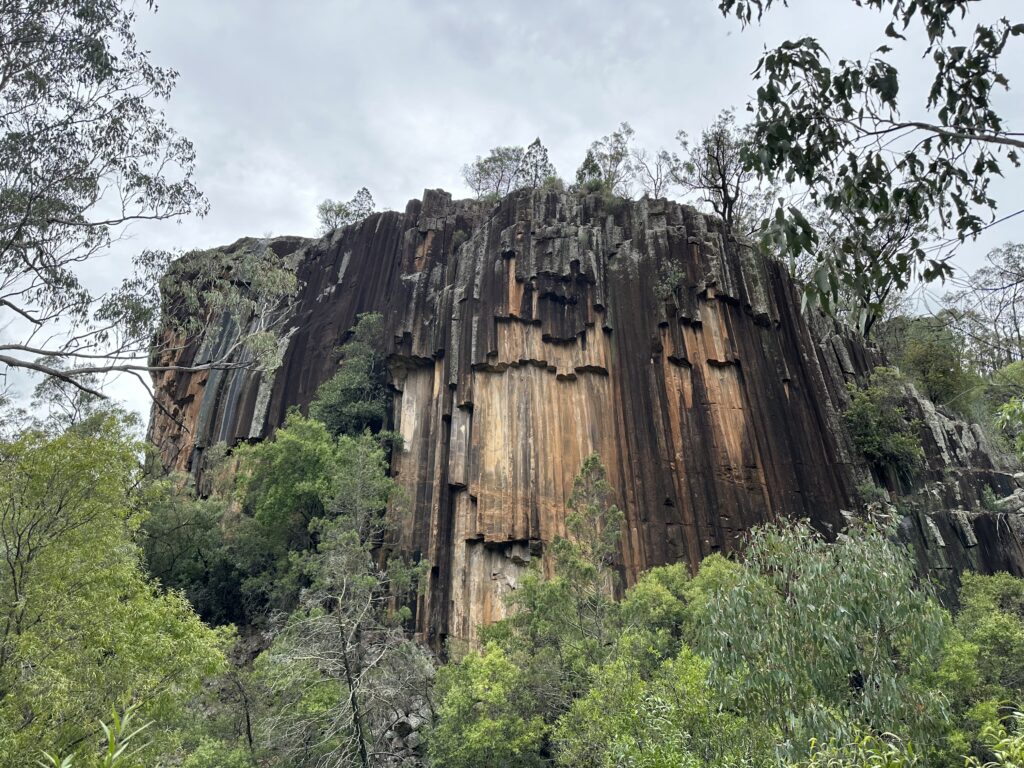
Ancient rock formations are a spectacular feature of the Narrabri region’s volcanic Nandewar mountain range – above and below the surface.
“Although we have similar geological settings elsewhere in NSW and Queensland, the well-developed groundwater monitoring bore network in the Narrabri region allows us to study how the different formations are linked or disconnected in more detail than elsewhere.”
“This means that we are able to collect environmental tracer samples at a high resolution allowing us to understand how groundwater flows within or across formations.”
Easier said than done. Over the past five years and three separate studies, Dr Raiber and his team have been challenged by floods, heatwaves, bushfires, Covid-19 lockdowns, and the dense bushland of the Pilliga State Forest itself.
Building on results of the previous studies, this latest project – Understanding connectivity between coal seams – will use geochemical modelling to learn more about the groundwater systems in the Narrabri Region, and create high-resolution 3D realizations of the subsurface formations.
Sky-high science
Part of this study included an airborne electromagnetic (AEM) survey in November 2023, to obtain in-depth information about the subsurface features of the Pilliga Forest and adjacent agricultural lands, to a depth of around 400m.
The survey involved a helicopter fitted with electromagnetic sensing equipment flying at low altitudes in parallel lines over the Pilliga Forest and nearby agricultural lands.
The information collected from the survey provides insight on the potential for hydrogeological pathways to connect deep coal seams and shallow aquifers.
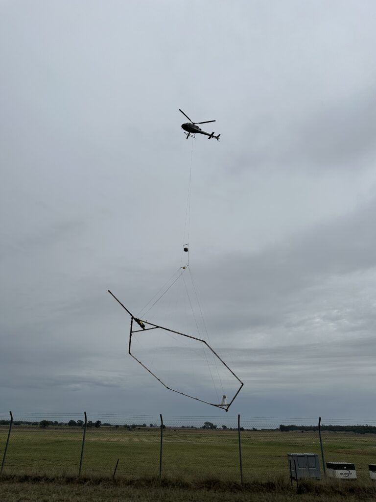
Take off – CSIRO’s Narrabri Airborne Electromagnetic Survey gets underway.
A key aspect of the AEM survey was an intensive community engagement program featuring advertisements in local media and contact with local businesses and community organisations, so that the local community had access to clear information about the survey and why it was being conducted.
AEM surveys are routinely used in Australia and around the world to gain valuable scientific data about groundwater and other geologic features. The aerial approach was necessary after previous attempts to conduct a ground-based survey yielded valuable but incomplete data due to the rough terrain of the Pilliga Forest restricting vehicle movement.
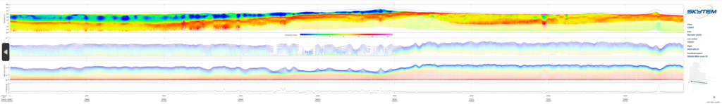
An example of subsurface data collected by CSIRO’s Narrabri Airborne Electromagnetic survey.
Filling in the research gaps
GISERA Director Dr Damian Barrett said CSIRO research into groundwater and subsurface characteristics in the Narrabri region reflected community concern on the potential for gas resource extraction to affect important shallow aquifers.
“This survey is important because it fills in the missing gaps about the geology of the region, from the surface to a depth of around 400 metres,” Dr Barrett said. “This data will help identify or rule out geological intrusions or faults from deeper formations into these relatively unstudied shallow surface formations.”
While CSIRO research to date has found no evidence of strong connectivity between the deep coal seam gas development zone and the shallow, agriculturally important aquifers, this new research addresses knowledge gaps identified in previous studies.
GISERA has undertaken eight projects in the region including community wellbeing, economic impacts of onshore gas development, biodiversity, groundwater, and microbial degradation of chemicals used in CSG activities.
Results from the current study will be publicly available on the GISERA web site later this year.
Learn about other GISERA projects in NSW.