Baselining groundwater and seismicity in the northern Perth Basin
Researchers from CSIRO, Australia’s national science agency, will use drill-free, non-invasive monitoring methods to establish baseline groundwater and natural seismicity levels across the northern Perth Basin.
This project is conducted through CSIRO’s Gas Industry Social and Environmental Research Alliance (GISERA) in collaboration with the Geological Survey of Western Australia (GSWA).
The GISERA research contributes to GSWA’s WA Array project, which is a network of seismometers being deployed across Western Australia to identify the composition and structure of the State’s lithosphere (earth’s crust and upper mantle).
In addition, the GISERA project seeks to address community concerns about the potential impacts of natural gas extraction in the region.
The northern Perth Basin is currently seeing a significant increase in energy-related industrial activities, including natural gas extraction. Local communities have expressed concern about potential impacts on groundwater resources and potential seismic activity.
The naturally occurring background seismicity of the region remains poorly documented due to the limited historical coverage by seismic stations. Instrumental coverage is still relatively sparse in the region, but the GSWA has recently deployed seismic arrays that will help provide new information.
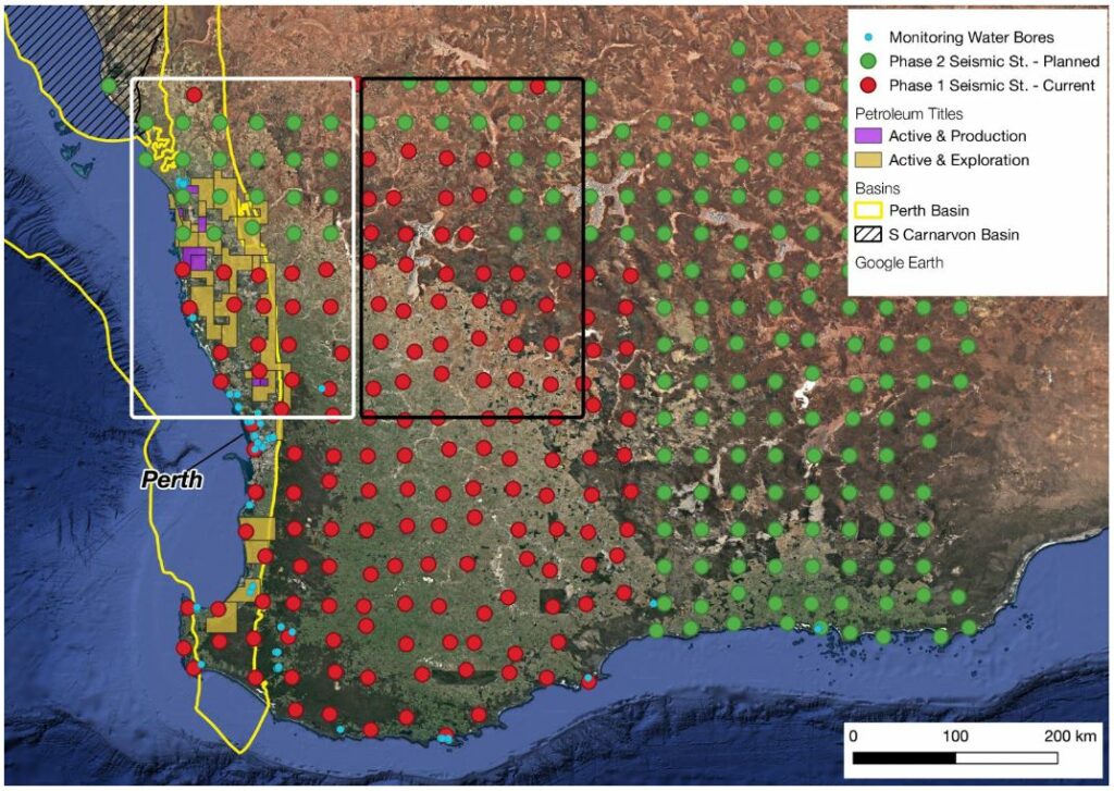
Current and planned passive seismic station distributions of the Geological Survey of Western Australia in Western Australia. Two rectangles show the regions of interests. The white rectangle shows stations that are partially located in northern Perth Basin and coinciding with petroleum titles. The black rectangle shows the location of seismic stations that are outside the petroleum titles and will be used as control group. Monitoring water bores are shown with blue circles (source: Water Corporation).
In this study, CSIRO scientists will monitor seismicity (the occurrence and distribution of earthquakes) and fluctuations in groundwater depths over the course of a year. This will allow the team to build a baseline catalogue of natural seismic activity that can be used to compare with future seismic events.
The baseline can help determine whether subsequent events are consistent with the current background activity in the region, or whether they may have other causes. It will also lead to a better understanding of variation in groundwater depth, and will provide the necessary context against which future variations – both natural and manmade – can be measured.
At a time when demand for groundwater resources is increasing, the results of this research will provide an important evidence base for informed decision making and sustainable resource management in WA.
Read more about this project and learn about other GISERA research in WA.