Understanding biodiversity impacts in the Northern Territory
Scientists from CSIRO, Australia’s national science agency, have mapped and quantified habitat connectivity and fragmentation data that can help manage potential impacts to biodiversity from roads and pipelines in the Northern Territory.
Proposed development of an onshore gas industry in the Northern Territory’s Beetaloo Sub-basin has prompted community concern around the impacts of roads, pipelines and other linear infrastructure on biodiversity and habitat.
Prior to the current research, information about the impacts of habitat fragmentation on Northern Territory biodiversity was scarce.
To address this knowledge gap, CSIRO scientists studied vegetation connectivity, the mortality of animals on different types of roads, and how the occurrence of animals and plants is influenced by the size of habitat patches.
Coordinated through the CSIRO’s Gas industry Social and Environmental Research Alliance (GISERA), the Understanding and managing impacts to biodiversity from roads and pipelines in the Northern Territory research project focussed on areas of the Beetaloo Sub-basin most likely to be affected by onshore gas development.
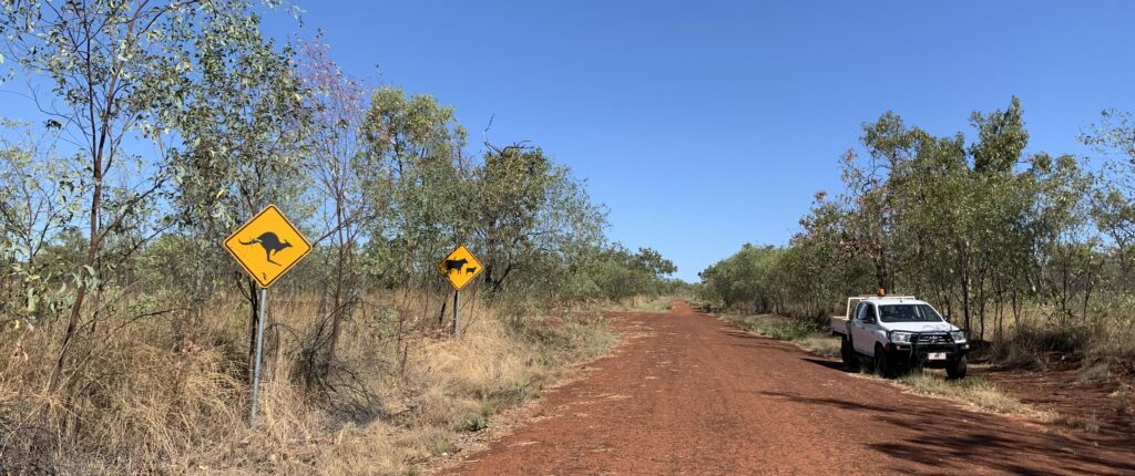
An unsealed road, Northern Territory.
Beetaloo habitat and connectivity
The Beetaloo Sub-basin contains a wide range of vegetation communities including savanna woodlands, grassland and the sensitive vegetation communities lancewood (Acacia shirleyi) and bullwaddy (Macropteranthes kekwickii ).
Lancewood and bullwaddy assemblages support species of plants and animals that the study team identified as being potentially at risk from development.
When a habitat has a high degree of connectivity, animal and plant species can move freely across landscapes.
Roads, pipelines and other linear infrastructure can lead to habitat fragmentation (a breakdown in habitat connectivity), which can create barriers to species’ movements and lead to mortality from vehicle collisions.
Project outcomes – mapping habitat
In this study, CSIRO scientists used remote sensing data to map vegetation connectivity and identify habitat corridors and links. Four representative sites, each 50 km x 50 km in area, were studied at resolutions of ten square metres using satellites.
The study showed that indicators of fragmentation and connectivity, originally designed for forest ecosystems, can successfully be applied to savanna and associated vegetation in northern Australia.
This connectivity mapping in the Beetaloo Sub-basin can be used to assess potential biodiversity impacts.
For example, the location of proposed well pads, new roads, tracks, and pipelines can be superimposed on regional habitat connectivity maps.
This allows planners to identify and minimise or avoid the intersection of linear infrastructure with high-value habitat areas in the landscape, including core habitat, bridges and branches among other landscape elements.
Project outcomes – patch mosaics
The assessment of patches of habitats – patch mosaics – focussed on bullwaddy and lancewood communities that potentially support the highest concentrations of species ‘at risk’ from linear corridors.
Small patches typically supported thicker stands of bullwaddy and were more productive with the highest concentrations of plant species, including resprouter species and rainforest trees, shrubs, and vines.
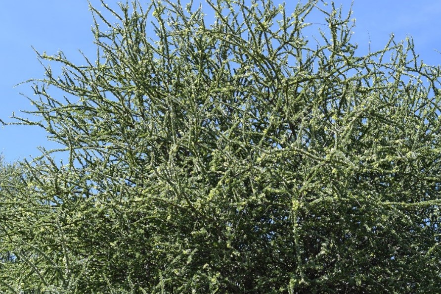
A Bulwaddy thicket (Macropteranthes kekwickii) in the Northern Territory.
Consistent with the findings for vegetation, vertebrate assemblages also differed according to patch size with small patches having a higher species richness (average of 27 species) than medium (19) and large (18) patches.
These results suggest that the species-rich small bullwaddy stands may be persisting as important low-flammability islands in the landscape matrix of highly flammable savanna. In contrast, the fire-sensitive lancewood is currently absent from portions of the landscape where fire is frequent.
Bullwaddy appears able to persist in this highly fire-prone landscape due to the exceptionally low ground fuel loads in bullwaddy-dominated patches. This persistence enables bullwaddy to support species that are disadvantaged by frequent fire.
Project outcomes – road mortality
Road mortality of vertebrates was assessed on three types of roads: primary highway, secondary highway, and secondary road; each of which had two replicate transects of 50 km in length.
Researchers identified each individual vertebrate killed or injured in a collision with vehicles along these transects.
Data were collected during three sampling periods: early dry season (June 2022), late dry season (November 2022) and the wet season (February 2023).
A total of 411 dead or injured native animals from 44 species were observed including mammals, frogs, reptiles, and birds. Body mass of roadkill species ranged from 90 kg (male red kangaroos) to seven grams (small birds).
Six species of macropods (kangaroos and wallabies) dominated the sample, making up 70 per cent of all roadkill. The number of macropods killed was high in the early dry and late dry seasons but declined during the wet season.
Reptiles and birds made up a higher proportion of road kills in the wet season than at other times of year. Frogs were only recorded in the wet season.
Traffic volumes on several roads, especially the Stuart and Carpentaria Highways, are predicted to increase markedly during the construction and operation phases of an onshore gas industry.
The study found this increase in traffic will likely result in an increase in wildlife-vehicle collisions and wildlife road kills.
Potential mitigation measures
Potential mitigation measures include road signs, vehicle speed limits, fencing roads to prevent access for wildlife, and habitat modification in the form of removing vegetation from the sides of the major highways during the wet season.
Wildlife crossing structures (overpasses, underpasses, wildlife bridges) are unlikely to be necessary in the study area. The reasons for this conclusion are a lack of evidence of ‘hotspots’ of road mortality and the lack of a target species, or group of species, that is likely to benefit sufficiently at the local population level from the presence of crossing structures to justify the costs.
Project funding
The project addresses in part recommendations 8.7, 8.9, 8.10 and 8.11 of the Scientific Inquiry into Hydraulic Fracturing in the Northern Territory (2018). The research was funded by the Federal and Northern Territory governments, industry and CSIRO.
Read the final report
Learn about other GISERA projects in the Northern Territory